Filter by:

Approach to Sydney Terminus showing Blackwattle Swamp

Blackwattle Creek

Author: Paul Irish and Tamika Goward Blackwattle Creek was originally a tidal watercourse that flowed from swampy lands that are now within the grounds of the University of Sydney. The creek flowed from this swamp through a valley thick with Read More

Goat Island midden

Aboriginal sites on Goat Island

Author: Paul Irish and Tamika Goward Goat Island is a small rocky landmass in the waters of Sydney Harbour. It was inhabited by early colonial Aboriginal identity Bennelong and his wife Barangaroo, and was said to have belonged to Bennelong’s Read More

Looking south along Botany Road

Moore Park Campsite

Author: Paul Irish and Tamika Goward An Aboriginal campsite was discovered in 2014 beneath the car park of the Moore Park Tennis Centre. It was unearthed during archaeological excavations brought about by the proposed construction of a light rail line Read More

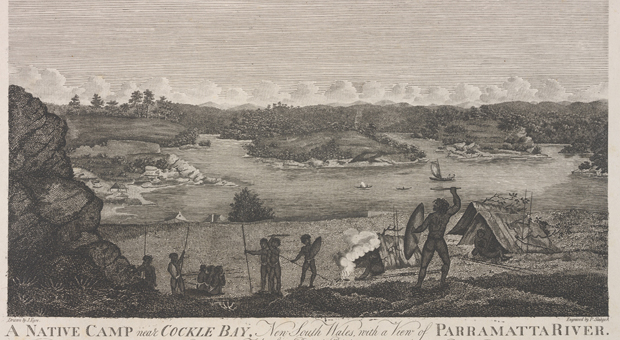
Aboriginal camp at Cockle Bay c 1812

Tinker’s Well

Author: Paul Irish and Tamika Goward All people depend on fresh water to live, and so it is usually the case that reliable sources of water known to Aboriginal people were later used by Europeans. The most permanent of these Read More

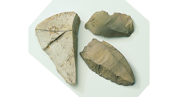
Stone artefacts from the Moores Wharf midden

Moores Wharf Midden

Author: Paul Irish and Tamika Goward In the late 1970s, the NSW Maritime Services Board began to redevelop the Moores Wharf area at Millers Point on the end of the eastern shore of Cockle Bay (Darling Harbour). The board decided Read More

Detail from an illustration of the engravings

Moore Park Engraving

Author: Paul Irish and Tamika Goward On a slab of sandstone just outside Centennial Park there were once some Aboriginal engravings. Rock engravings were produced when Aboriginal people carved them onto level sandstone platforms, ledges or small rock exposures. They Read More

View from the Government Domain

Yurong Cave and Yurong Midden

Author: Paul Irish and Tamika Goward Yurong Point is known today as the site of Mrs Macquarie’s Chair, a seat carved from stone in the 1810s so Governor Lachlan Macquarie’s wife Elizabeth could enjoy the view of the harbour. It Read More

William and Riley Street Hatchet

William Street

Author: Paul Irish and Tamika Goward In 1925, a stone axe was found more than five metres below the surface during construction work at the corner of William and Riley Streets in East Sydney. Almost eighty years later in 2003 the Read More

St Mary's Hatchet

St Mary’s Cathedral Hatchet

Author: Paul Irish and Tamika Goward An Aboriginal stone axe head, also called a ‘ground-edge hatchet’, was found in a road cutting behind St Mary’s Cathedral in 1876. The hatchet would have started its life as a large flat river Read More

Stone artefacts from the KENS Site

The KENS Site

Author: Paul Irish and Tamika Goward In 2003, archaeologists discovered a large Aboriginal campsite in the western part of central Sydney. It was named the KENS Site after the surrounding streets (Kent, Erskine, Napoleon and Sussex). The earlier building had Read More

Woolloomooloo

Junction Lane Campsite

Author: Paul Irish and Tamika Goward In 1997, an Aboriginal campsite was discovered at Junction Lane in Woolloomooloo during archaeological excavations ahead of the construction of the Eastern Distributor motorway. Underneath around a metre of recent ‘fill’ (historically deposited material Read More

Conservatorium of Music

Conservatorium of Music

Author: Paul Irish and Tamika Goward In 1998, some Aboriginal stone artefacts were found during archaeological excavations ahead of the redevelopment of the Sydney Conservatorium of Music on Macquarie Street. The excavations were being undertaken to investigate an area of Read More

Stone artefacts from the Wynyard Walk Aboriginal campsite

Wynyard Walk campsite

Author: Paul Irish and Tamika Goward During archaeological excavations associated with the construction of the Wynyard Walk pedestrian link in mid-2014, a small Aboriginal campsite was located. The campsite consisted of several Aboriginal stone artefacts located in natural soil underneath Read More

Aboriginal midden

Darling Walk Midden

Author: Paul Irish and Tamika Goward In 2009 archaeologists found an Aboriginal campsite, or ‘midden’, on the eastern side of Cockle Bay (Darling Harbour) in an area known as the Darling Quarter, west of Harbour Street, between Bathurst and Liverpool Read More

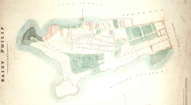
Parish Map of St Philip

Dawes Point / Tar-Ra

Author: Paul Irish and Tamika Goward The Aboriginal name for the peninsula on the western side of Sydney Cove is Tar-Ra. It is also known as Dawes Point because it was the site of an observatory built in April 1788 Read More

A portrait of Bennelong

The site of First Government House

Author: Paul Irish and Tamika Goward Sydney’s first Government House overlooking Sydney Cove was built for Governor Arthur Phillip in 1789. The building and its grounds were an important place of early contact and cross-cultural exchange between Sydney’s Aboriginal population Read More

John Lewin, ‘Fish catch and Dawes Point Sydney Harbour’

Lilyvale Campsite

Author: Paul Irish and Tamika Goward The Rocks area is mainly known as a place of early European history, but it was also used by Aboriginal people for many years before colonial settlement. Traces of an Aboriginal campsite have been Read More

Excavation at Sheas Creek

Sheas Creek (Alexandra Canal) Alexandria

Author: Paul Irish and Tamika Goward At Beaconsfield in the 1890s, workers on the Alexandra Canal began cutting through the sediments of Shea’s Creek and made some remarkable discoveries. The sediments were several metres deep and contained layers of shell, Read More

Stone artefacts from the Angel Place site

Tank Stream Sydney

Author: Paul Irish and Tamika Goward Central Sydney is built in the Tank Stream valley. The Tank Stream now runs underneath the city, but its fresh water was one of the main reasons why Europeans set up camp in Sydney Read More